Saturday, June 15

Kilfenora

 Tour Buses outside of Dublin, on the road thru the Burren and at the Cliffs of Moher were the first times that we really encountered tour buses in force. They just barrel along and they have right of way, so you really have to move over to avoid them. On the other hand they were great to follow on the narrow roads  because they moved everyone else off to the side of the road and we just rolled on behind them.
 After leaving the cliffs we headed to Kilfenora where the Burren Center was located. We had plans on doing a hike in the Burren the next day and wanted to see what the options were. Along the way we passed another of these block tower castles. Built in the 14th and 15th centuries to protect wealthy chieftains they are located thru out Ireland. Some have actually been restored and are used as guest houses. We learned that inside the stair case went up counterclockwise around the outside walls so that the defenders when coming down from the top floors would have the advantage with their swords free.
We got to Kilfenora late in the afternoon, and after visiting the Burren Visitor Center, decided that we would not do any of their hikes. Next door to the center is the Kilfenora Cathedral. Our guidebook said that the church next door to the Visitor Center had a couple of crosses but wasn't much to see,
 but looking over I saw the the church had what looked like a  plexiglass roof over one section, so we ambled over and had to walk over some gravestone to find the entrance.

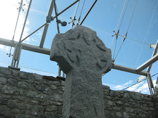
We found that a lot of work had been done inside the cathedral and that a new exhibit had been just completed inside with lot's of graphics and descriptions. We found that originally their was a monastery built here around 540 AD and later around 1189 the Cathedral had been built. The glass roof has been added to help preserve the interior and to cover the crosses. Of the seven high crosses that were originally in the area 3 remain well intact. They were carved out of limestone about the same time that the Cathedral was built and are quite ornate. The crosses had been located outside on the intersections of the roads leading into Kilfenora.  The Doorty cross above has a bishop with a staff
The cross above is the North Cross with ornate carvings and below one of the windows with a Bishop's head. It was all quite impressive and we were glad we had discovered it.


Monday, June 3

the Burren and the Cliffs of Moher


We were in the area of the Burren for 2 days. The first passing through to the cliffs of Moher.  the Burren is an area of limestone hills. 6000 years ago there were trees and grass covering the underlying rock, but the first settlers cut down the trees and their cattle ate the fragile grass, so that now all the rock is exposed. Over the years a combination of water n the limestone has eroded the Burren so that there the rock is cracked and drilled. Holes an cracks everywhere. Gricks and Gracks they are called. Wildflowers abound in the holes that have accumulated a little dirt. 


This area is along the coast so the winds and salt spray from the Atlantic continue to effect the area. We headed inland a bit and found a castle set back from the road.

This one looked like it might have been in recent use as there was glass in the windows.  And in the distance we see the Cliffs of Moher

These cliffs are 800 feet high  and extend 8 km along the coast south of Doolin and are now home to countless birds including puffins, gannets, kitiwakes, gulls. We saw the cliffs from the ocean and then on top. We had a boat ride scheduled at noon and although it was a sunny day the winds were nice and strong and the seas running 4 to 5 feet. A rocky ride out and back to the cliffs.


I went to the top of O'Brien's castle but the ramparts blocked some of the view from the top. nice circular staircase going up. O'Brien's castle was built as a lookout tower in 1835.


Saturday, June 1

Travel by picture

I am going to try to bring you to where we are by just posting some of the pictures of the places we have been and things we have seen. I will try to put a short explanation below the photographs.

This was a replication of the tile flor in St. Patrick'sCathedral

 
Croagh Patrick


Sheep in the road. They get out of the way pretty fast so it's just a matter of slowing down a bit.

Fixer upper

Feasting on Prawns. We ave been feasting on a lot of different meals. lots of fish for me. The Atlantic seafood Chowder has been especially good. Bill Jordan who makes a good fish chowder could take note. The last one i ate had mussels, salmon, shrimp, clams, white fish and was really good. Ellen's prawns were very good. I was allowed to taste one.


Wildflowers are out.  


Ballyconeely. This is still in the Roundstone area.  We were told that there were a lot of Keogh's here and they also own the pub in Kinvera which we will see later on. Was not crowded the night we ate dinner there.


Ivy Rock B&B Roundstone

View from Ivy Rock looking towards Inisheer.  You can just see the bridge going to the island.


O'Dowds pub Roundstone. Good meals!!


My new hat and the Giant of Connemara heading towards Kinvara.


Lunch spot in Kinvara and then onto the Castle DunGuaire for our Medieval Banquet. The food was really good, as was the evenings entertainment. We were welcomed into the castle with a mug of mead and then climbed a circular stair to the banquet hall.


Wild flowers growing in the castle wall


Another castle we came upon. We passed a few that there was no place to stop and take a picture which was disappointing, but they are really dramatic when you are driving along and one pops into view. I am going to leave you here in Kinvara, while I write up our trip through the Burren and our visit to the cliffs of Moher.


Roundstone, County Galway


Roundstone, is the only townland that I can positively identify as a place that my paternal Irish forbears lived. Family tradition has it that the Keogh's originally came from County Tipperary and that in Ireland they used the Mc prefix. But from family death certificates I learned that some of the family was born in County Galway and that one of their daughters was married in Roundstone. The english did 2 surveys of Ireland recording everyone who owned land and their tenants. They also mapped all the properties. These are the only records that are still in existence and provide a way of finding your family. The Keogh's were not in Roundstone in 1848, fo the first valuation but Bridget McKeogh is listed in the 1855 valuation. My speculation is that they were evicted from their lands after their famine and sent to the west of Ireland either to perish or immigrate by their British landlords. So I had a plot of land to find and of course in today's world it is much easier now that we have digitized the world. It was an easy matter of taking the ordinance survey maps and layering them with Google Earth. So we found the plot that she was listed with probably much as it was in 1855, with 2 lots with houses on either side and hers a vacant rocky and today covered with Gorse.

I actually had to untie a gate to get on the property and then tie it up when we left.


Then on to the cemetery. Bridget's husband Denis never came to the States, so I was hoping to find a tombstone marking his grave and one of his son-in-laws as well. The cemetery is on Gurten Bay, one of the nicest beaches we have been to, but we could not find any markers that predated 1890. I asked one of the men who was working on a grave about the lack of early dates and he told me that in the early days boulders were placed on the graves to mark them. We of course have no one to point to a particular stone and say that is where Denis is.


Certainly couldn't find a cemetery with a better view, looking either back to the mountains or out to the sea. We were also advised that we could try the Insheer Island cemetery so we headed that way. It is on an island, actually across the street from our B&B. Easy drive over and across the bridge and then the small 2 lane road went to one. Up and down and around the bends praying that another car wasn't trying to head our way. We found the cemetery 3/4's of the way around the island but it was the same story- lots of boulders on the ground. leaving the cemetery the road deteriorated  to such an extent that we turned around and headed back off the island passing a pony.


I am happy with what I have found so far and this will conclude for a couple of days my search for family. Next week on our way to Cashel Rock we will stop in Tipperary briefly to see if we can pin the keogh's down a bit better. So now ellen & I are off touring and heading for Kinvera, Milltown Mabay, before heading to Dingle.